

In a significant update, Google has enhanced its popular navigation service, Google Maps, with exciting new features that allow users to delve into the past and explore even more remote locations. This update is not only about navigation; it also opens doors to historical exploration and visual storytelling, making Google Maps an even more versatile tool for users worldwide.
A Time Machine at Your Fingertips
One of the standout features being introduced is the ability to access historical imagery, effectively allowing users to “travel back in time.” This feature provides a unique opportunity to view aerial and satellite images that can date back as far as 80 years in certain regions. For major cities like Berlin, London, Paris, and Warsaw, historical imagery reaches back to the 1930s, offering an invaluable glimpse into how these urban landscapes have evolved over decades.
This addition is not just for casual exploration; it has practical applications for researchers, historians, and environmental scientists. For instance, urban planners can analyze the changes in land use, while environmentalists can study the impact of climate change on natural landscapes. This feature can help in understanding how human activity has shaped our environments over time, providing a richer context for contemporary issues.
As users navigate through these historical images, they can witness how neighborhoods have changed, how forests have transformed, and how urban development has taken shape. The potential for educational purposes is immense, making this feature a powerful tool for schools and institutions.
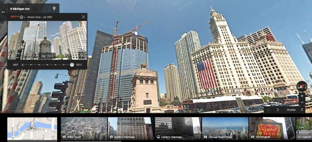
Expanding Street View Coverage
Alongside the historical imagery feature, Google is also significantly expanding its Street View capabilities. With this update, Street View is set to be accessible in nearly 80 additional countries, broadening the scope of places users can explore virtually. This expansion is one of the most substantial updates to the Street View service since its inception, which began capturing images back in 2007.
Google’s Street View has amassed over 280 billion images from various locations around the globe, captured by cars, trekkers, and other means of transportation. The new expansion will allow users to explore diverse landscapes, from the picturesque countryside of Bosnia to the medieval villages in Europe and the sandy mountains of Namibia. Each new addition brings with it the richness of culture and geography, enhancing users’ ability to explore parts of the world they may never visit in person.
This update caters not only to travel enthusiasts who wish to plan their next adventure but also to those looking to learn more about different cultures and regions from the comfort of their homes. By providing an immersive visual experience, Google is effectively transforming the way people can connect with the world around them.
Enhancing Satellite Imagery
In addition to the time travel feature and Street View expansion, Google is improving the quality of satellite imagery across both Google Maps and Google Earth. Utilizing advanced AI technologies, the company is implementing a new model called Cloud Score+, which is designed to enhance image clarity and vibrancy. This model leverages millions of images to detect and eliminate issues such as cloud shadows, haze, and mist.
The result is a brighter and more vibrant representation of the Earth, providing users with an improved visual experience. Whether you are exploring mountain ranges, urban landscapes, or oceanic views, the enhanced imagery allows for a more accurate and engaging representation of our planet. This upgrade not only benefits casual users but also serves professionals in various fields, including environmental science and urban planning.
Practical Applications and Benefits
The updates to Google Maps, particularly the introduction of historical imagery and expanded Street View, have numerous practical implications. For educators, these features can serve as powerful teaching tools. History classes can benefit from visual aids that show the evolution of cities, while geography lessons can incorporate real-world examples of climate change and urban development.
Researchers in environmental sciences can utilize historical imagery to monitor changes in ecosystems, while urban planners can analyze patterns of development and land use over time. This feature also holds potential for journalists and storytellers, who can use historical data to enrich their narratives and provide context to current events.
Additionally, businesses involved in tourism, real estate, and urban development can leverage these updates to offer better services. For example, real estate agents can showcase neighborhood transformations over time, while tour operators can provide virtual experiences that highlight historical and cultural significance.
Conclusion
The recent updates to Google Maps, including the introduction of a time travel feature, the expansion of Street View to nearly 80 additional countries, and enhancements to satellite imagery, represent a significant evolution in how users interact with mapping technologies. These features not only enhance user engagement but also provide valuable tools for education, research, and planning.
As technology continues to advance, Google Maps is positioned to remain at the forefront of digital navigation and exploration. With its commitment to improving user experience and providing access to rich historical and geographical data, Google Maps is not just a navigation service but a portal to understanding our world and its history. Whether for casual browsing or serious research, these updates ensure that users can engage with the planet in deeper and more meaningful ways. As these features roll out, users are sure to find themselves discovering new facets of familiar places and exploring the hidden gems of our shared global heritage.